


FOREST - T 2 Voting District, Fond du Lac County, Wisconsin
About
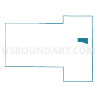
Outline

Summary
| Unique Area Identifier | 693780 |
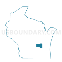
| Name | FOREST - T 2 Voting District |
| County | Fond du Lac County |
| State | Wisconsin |
| Area (square miles) | 6.97 |
| Land Area (square miles) | 6.95 |
| Water Area (square miles) | 0.02 |
| % of Land Area | 99.68 |
| % of Water Area | 0.32 |
| Latitude of the Internal Point | 43.79735320 |
| Longtitude of the Internal Point | -88.23291070 |
Maps

Graphs
Select a template below for downloading or customizing gragh for FOREST - T 2 Voting District, Fond du Lac County, Wisconsin


Neighbors
Neighoring Voting District (by Name) Neighboring Voting District on the Map
- EMPIRE - T 3 Voting District, Fond du Lac County, WI
- FOREST - T 1 Voting District, Fond du Lac County, WI
- MARSHFIELD - T 1 Voting District, Fond du Lac County, WI
- MARSHFIELD - T 2 Voting District, Fond du Lac County, WI
- TAYCHEEDAH - T 2 Voting District, Fond du Lac County, WI
Top 10 Neighboring County Subdivision (by Population) Neighboring County Subdivision on the Map
- Taycheedah town, Fond du Lac County, WI (4,205)
- Empire town, Fond du Lac County, WI (2,797)
- Marshfield town, Fond du Lac County, WI (1,138)
- Forest town, Fond du Lac County, WI (1,080)
Top 10 Neighboring Unified School District (by Population) Neighboring Unified School District on the Map
Top 10 Neighboring State Legislative District Lower Chamber (by Population) Neighboring State Legislative District Lower Chamber on the Map
- Assembly District 53, WI (59,677)
- Assembly District 52, WI (56,377)
- Assembly District 27, WI (56,118)